The Cartographer's Sinking Continents
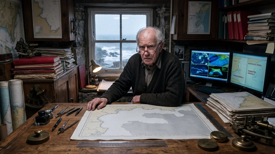
Julian Haze spent forty-four years cataloging the exact coordinates of the Earth for the Directorate of Hydrography, but in the quiet winter of his seventy-first year, the world began to unspool from his mind in direct proportion to its sudden, unexplainable expansion on the surface of the sea. Whenever a town, a mountain pass, or a coastal promontory evaporated from his memory—leaving behind only a gray, painless void where decades of geography had once rested—an impossible landmass would quietly resolve on the high-resolution synthetic aperture radar feeds of the world’s marine satellites. Convinced that his encroaching dementia was not a biological collapse but an ontological migration, Julian embarked on a final, obsessive survey from his salt-bleached cottage on the Northumbrian coast, watching his own youth, his late wife’s hometown, and the great cities of his career trade places with basalt reefs, mist-shrouded atolls, and salt-choked archipelagos that no vessel had ever sailed.
I. The Drafting Table
The house sat on a shelf of limestone three hundred yards above the North Sea, where the wind carried the smell of rotten kelp and wet coal dust. For forty years, Julian had spent his evenings at a heavy drafting table constructed from teak salvaged from a Victorian lightship. The table possessed brass gimbals, a counterweighted parallel bar, and a surface scored with thousands of razor-thin incisions from scalpel blades, ruling pens, and divider points.
On the third of November, Julian sat before a blank sheet of 90-pound Arches hot-pressed watercolor paper with a pair of nickel-plated dividers held lightly between his thumb and forefinger. He intended to sketch from memory the approaches to the port of Bergen—a fjord he had sounded himself in the summer of 1978 during a joint survey with the Royal Norwegian Navy. He could remember the cold grease of the survey vessel’s winches; he could remember the taste of the chicory coffee the helmsman brewed in a dented tin pot; he could even remember the blue woolen socks Clara had knitted for him, which smelled like sheep grease whenever the deck took spray.
Yet, when he touched the needle point of the dividers to the paper to set the scale, the fjord was gone.
It was not gone in the manner of an elusive word that lingers on the tip of the palate, vibrating with its own absent syllables. It was gone as though the space between sixty degrees north and five degrees east had never contained water, rock, or timber. When he looked inward, into the vast, cataloged card index of coastlines he had carried behind his eyes since his apprenticeship at Taunton, he found only a flat, gray smudge. Where Bergen ought to have been—with its seven hills, its funicular railway, and its fish market reeking of ling and vinegar—there was only an empty shelf of oceanic nothingness.
Julian lowered the dividers. The brass arm clinked faintly against a porcelain cup half-full of cold tea.
"Bergen," he said aloud. The word felt like dry leaves inside his cheek. A phoneme without anchorage. He tried to visualize the lighthouse at Marstein. Nothing. He tried to summon the narrow channel of Byfjorden. The memory was not dark; it was untextured, like fresh vellum before the ink-cake has met the well.
He rose from the stool, his hip clicking with the dry, arthritic pop that had replaced the sound of his morning runs three years ago, and walked across the linoleum to the corner where his workstation hummed. The workstation was a concession to modernity forced upon him by his former department upon his retirement. It consisted of a dual-monitor rig running a secured, read-only terminal link to the Sentinel-3 ocean-monitoring array and the Admiralty’s Bathymetric Data Center at Taunton. Julian was still technically retained as an "emeritus consultant," a bureaucratic euphemism that allowed the young hydrographers in Somerset to ping him when an old lead-line sounding from 1922 contradicted a multi-beam sonar sweep from a modern survey vessel.
The screens cast an anemic, phosphor-blue light across the stacks of Admiralty charts, Admiralty Sailing Directions, and red-bound logbooks that lined his walls from floor to ceiling.
He opened the live European Space Agency marine feed. He zoomed in on the North Sea basin, expecting to see the familiar ragged coast of western Norway—the great, fractured spine of rock he had known better than the bones of his own hand.
The coast was there. Bergen was there, its harbor lights clearly visible as tiny citrine pinpricks piercing the winter cloud cover on the optical layer. The world had not forgotten Bergen. Only Julian had.
He let out a short, self-deprecating breath, the sort of laugh an old man gives when he realizes he has put his spectacles into the refrigerator. "Stroke," he muttered to the empty room. "A transient ischemic event. A small clot in the left parietal lobe, clipping the cable to the filing cabinet."
He reached for the mouse to shut the array down, but an anomalous return on the western edge of the display caught the corner of his eye.
Julian leaned closer, his nose nearly touching the anti-glare coating of the primary monitor. Two hundred miles southwest of Ireland, out where the Celtic Sea plunged over the continental margin into the abyssal plain of the Porcupine Seabight, there was an anomaly in the radar altimetry data.
The satellite had flagged it as an automated artifact—a cluster of rogue swells, perhaps, or an uncalibrated atmospheric backscatter from a rain cell. But Julian had spent forty years reading the gray-scale grain of sea-state radar. This was not a swell. The returns had hard, unyielding edges that threw crisp shadows back toward the pulse of the satellite's synthetic aperture.
It was an island.
It was small—perhaps three nautical miles from its northern horn to its southern spit, curved like a cashew nut. Its highest contour, according to the interferometric elevation data, rose sixty-eight meters above mean high water springs.
Julian pulled his reading glasses down his nose and tapped the keyboard. He queried the Admiralty digital chart database for sector Q-44.
The sector was empty. For five hundred miles in every direction, the chart showed only blue water, broken only by sounding numbers: 2,100, 2,450, 2,800 meters. There were no banks, no shoals, no seamounts rising higher than twelve hundred meters below the surface.
Yet the Sentinel satellite, passing five hundred miles overhead in the cold vacuum of twilight, saw rock. It saw cliffs of dark basalt against which the long Atlantic fetch was breaking into white lace.
Julian reached for a pencil, then stopped. He looked back at his blank sheet of Arches paper.
He tried, with a sudden, violent surge of will, to remember the name of the hotel where he and Clara had stayed in Bergen during that wet July in 1978—the one with the brass birdcage in the foyer and the smell of boiled salt mutton coming up through the floorboards.
The room remained dark. The memory was not merely lost; it was displaced.
He looked back at the cashew-shaped sliver of rock on the monitor. Its northern hook had two small indentations that resembled, with an unbearable, mathematical precision, the twin coves flanking the entrance to Bergen’s outer harbor.
II. The Bathymetric Clinic
By mid-December, the winter had set its teeth into the headland. The gorse bushes along the path to the village were coated in glass-clear ice that rattled like bone buttons in the gale.
Julian sat in a small, windowless consulting room at the Royal Victoria Infirmary in Newcastle, his hands folded across the knees of his corduroy trousers. Across the laminated desk, Dr. Alistair Finch—a neurologist with wrists so thin they looked as though they might snap under the weight of his stainless-steel chronograph—was flipping through a sheaf of magnetic resonance printouts.
"The structural images are remarkably clean for seventy-one, Julian," Finch said, using the overly bright, level tone reserved for men who were about to deliver bad news disguised as normal aging. "The vascularization is good. There’s no evidence of infarcts, no micro-bleeds in the deep white matter. The hippocampus shows some minor bilateral volume loss, but it’s well within the expected percentile for your age bracket."
"Then why can’t I remember the name of the river that runs through Lisbon?" Julian asked. His voice was flat, dry as pumice.
Finch smiled sympathetically. "Nominal aphasia is common. We all lose proper nouns as the retrieval networks lose their plasticity. You’ve had a massive amount of spatial data in your head for half a century. The brain is an efficient pruner. If you haven't consulted a specific chart in fifteen years—"
"I consulted Lisbon three weeks ago," Julian interrupted. "I was looking at a facsimile of the 1755 survey after the earthquake. I knew the river. I have sounded the bar at its mouth. I knew the depth of the mud at the anchorage off the Belém Tower: nine fathoms at low slack, soft silt over gravel. Now, I do not know the river's name. I do not know if the water is fresh or salt. When I say the word Lisbon, I see only a flat, white board. Like an unpainted wall."
Finch set the scans down. His fingers made a faint drumming noise on the desk. "Memory isn't a map, Julian. It isn't engraved on copper plates. It’s an active reconstruction. When we recall an event or a place, we aren't opening a drawer; we are re-performing the play. Sometimes the actors forget their cues."
"And if the stage burns down?"
"We manage the symptoms," Finch said gently. "I can refer you to the cognitive assessment unit in Durham. There are trials with acetylcholinesterase inhibitors. But frankly, if your memory is failing only along these narrow, domain-specific tracks—if you are still managing your bills, your cooking, your personal care—we may simply be looking at a very unusual, benign presentation of age-associated memory impairment."
Julian looked at the doctor's wall. Hanging behind Finch was a cheap, framed print of an eighteenth-century double-hemisphere projection—a decorative monstrosity with fat-cheeked cherubs blowing gales into the corners and California depicted as an island.
"That chart is wrong," Julian said, pointing a finger with a yellowed nail at the frame.
"Well, yes," Finch laughed. "It’s from 1720. They didn't have the satellites."
"No," Julian said. "Not California. The Strait of Malacca. The cartographer has pinched the narrows between Sumatra and the peninsula by forty miles. If you sailed that course on that projection, you would put your keel into the sandbanks off Malacca Town before the lookout could even drop the lead."
Finch looked at the print, then back at Julian, his eyebrows knitting into an expression of polite bewilderment. "I'll take your word for it, Julian. You're the map man."
On the train back to Berwick-upon-Tweed, Julian sat with his forehead pressed against the cold, vibrating double glazing. The fields of Northumberland rolled past—pale, stubbled rectangles of winter barley, rows of wind-flattened hawthorn, the distant, pewter smudge of the sea.
He closed his eyes and attempted an exercise.
Point A: The harbor of Valparaíso.
He reached into his mind for the great crescent bay where he had spent three months in the autumn of 1985, recalibrating the Chilean naval charts after an earthquake had shifted the harbor floor three feet to the northwest.
Nothing.
The memory was gone. Not just the name—the entire geography was gone. He could not remember if the Pacific was to the west or the east. He could not remember the smell of the fish-meal factories that had drifted out across the roadstead every evening at sunset. He could not remember the face of the pilot who had taken him out to the sounding boat—a man named Gabriel, or perhaps Guillermo, who had lost three fingers to a sharkline off Antofagasta.
He opened his eyes. He reached into his coat pocket and pulled out his smartphone—a cheap device he used only for emergencies. He brought up the marine tracking application he had linked to his Taunton account.
The phone took twenty seconds to buffer the satellite data over the weak rural cell towers.
When the vector map of the South Pacific resolved, Julian saw it.
Six hundred miles off the coast of northern Chile, far out in the dead, nutrient-poor desert of the subtropical gyre where nothing existed except three thousand fathoms of black water, a new landmass was registered in the database.
It was roughly forty miles long, shaped like a ragged crescent. The bathymetric layer showed that its eastern shore dropped into a natural, deep-water amphitheater with depths shelving abruptly from five hundred fathoms to nine.
A small icon pulsed next to the feature:
UNVERIFIED SHOAL / RADAR ANOMALY / ID: PAC-2024-0988.
Julian leaned back into the coarse fabric of the train seat. His heart was not racing; it had slowed to a heavy, dull thud that felt like a piston stroke in an engine room.
The crescent of the new island was identical to the shape of the roadstead at Valparaíso. The harbor mouth faced north-northwest, exactly as the Chilean port had faced, shielding its nonexistent anchorages from the great southern swell.
He had not forgotten Valparaíso.
Valparaíso had been evicted. It had been pulled out of his mind by some dreadful, hydraulic suction and cast out into the emptiness of the sea, where it was currently hardening into basalt, guano, and salt.
III. The Architecture of Loss
The correspondence began on the twenty-second of January.
Julian’s home terminal received an encrypted telex from the Hydrographic Office in Taunton. It came from Dr. Aris Thorne, a woman of forty who had been Julian’s last junior surveyor before he stepped down. Thorne was a brilliant geodesist who had done her doctoral work on satellite laser altimetry and who treated the physical Earth with the mild, affectionate contempt of someone who believed reality was merely an imperfect rendering of a mathematical model.
HAZE, J. —
Check the Sentinel-2B optical passes over the South Atlantic (Sector 72-B). We are seeing recurrent false-color returns sixty leagues east of the Tristan group.
Automated filters flagged them as cloud shadows, but the SAR backscatter gives a surface roughness value of 0.42—consistent with dry shale or lichen-encrusted volcanic scree.
Taunton IT thinks it’s an algorithmic glitch caused by the new calibration routines for the Copernicus ocean-color sensor.
I looked at the raw returns. Julian, they look like cliffs.
Tell me this is an instrument ghost. I don't need another island on my plate when the funding review is next month.
— Aris.
Julian did not reply via email. He went to his desk, took a clean sheet of heavy Basildon Bond paper, and uncapped his fountain pen. His hand was remarkably steady.
Dear Aris, he wrote.
It is not an instrument ghost. The cliffs you are looking at are approximately one hundred and forty feet high. On their landward side, they slope down toward a gravel outwash plain that drains into three small, brackish lagoons. The gravel is composed of crushed slate and red sandstone. If you were to land a dinghy there—which I do not advise, as the surge over the bar is treacherous—you would find that the vegetation consists largely of sea-holly, dwarf willow, and a species of bitter cress that smells of turpentine.
He stopped. He stared at the wet black ink.
He had never been to the Tristan group. He had never in his life studied an island sixty leagues east of Tristan da Cunha.
Yet he knew the taste of the cress. He knew the way the shale rattled beneath an iron-shod heel when one climbed the third ridge toward the interior.
He closed his eyes.
Where is the Isle of Wight? he asked himself.
He waited.
He waited for the white chalk needles to rise in his imagination. He waited for the memory of the ferry crossing from Lymington with his father in the summer of 1961, the taste of the raspberry ice cream that had melted down his wrist, the sight of the Victorian gun emplacements crouching like concrete badgers on the cliff tops.
Nothing.
The Solent was an open sea. The English Channel merged with Southampton Water without an impediment. There was no island. The space was smooth, blue, and clean.
Julian looked down at his letter to Aris. He added a postscript:
Do not send a survey vessel to the Tristan anomaly. They will find only what has already been discarded. Check your home coordinates, Aris. Look at your mantlepiece. Tell me if the pewter mug you won at the Dartmouth regatta is still there, or if you can only remember the shape of the space it occupied.
He did not mail the letter. He folded it twice, creased it with the edge of his bone folder, and placed it inside a lead box where he kept his spare surveyor’s compasses and his dead wife’s wedding band.
That night, Julian had the dream for the first time.
He was walking through an endless city that was also a swamp. The buildings were made of wet, gray chart-paper, their facades covered in fine copperplate script: Soundings in Fathoms, Magnetic Variation 4°15' W (1982), Caution: Cable Area.
As he walked, his shoes were soaked not with water, but with India ink. Every step he took blotted out three lines of latitude. Behind him, the streets were collapsing into black troughs that smelled of dead sea-urchins and cold granite.
In the center of the city stood Clara.
She was wearing the yellow oilskin coat she had worn during their surveys of the Pentland Firth in the early seventies. She was holding a six-inch brass sextant to her eye, sighting not on the sun or the horizon, but on Julian’s forehead.
"You're off by five minutes of arc, Julian," she said. Her voice sounded like sea-pebbles turning in the under-tow. "You haven't applied the index error. You’re putting us on the rocks."
"Clara," he said. "Where was our house in Bristol? The one with the bay window that looked down on the floating harbor?"
She lowered the sextant. Her face had no features; it was merely an oval of smooth, unprinted vellum, watermarked with the royal cypher of King George VI.
"It has just surfaced," she told him, "thirty miles off the coast of Mauritania. The fishermen from Nouadhibou are already laying their octopus traps in the scullery."
IV. The Mechanics of the Seep
By the end of February, Julian had established the ratio.
He kept a ledger—a large, folio-sized accounting book with ruled blue lines and a spine of red buckram. On the left-hand page, he recorded his losses. On the right-hand page, he recorded the coordinates of the new landmasses as they appeared on the international maritime telemetry.
The correlation was linear, elegant, and horrifying.
A small loss—the memory of an afternoon spent surveying an oyster bed in the mouth of the River Blackwater, including the names of the three mud-channels and the tavern where they had eaten pickled cockles—yielded a low-lying skerry or a sand-cay of approximately four to six acres in the mid-Atlantic.
A moderate loss—the complete spatial and episodic recollection of the city of Dundee, where he had lived for two years while attached to the Tay Estuary Research Group—produced a substantial island: nine miles long, with a central plateau rising to four hundred feet, complete with drainage networks that mirrored the course of the Tay and its tributaries, appearing out of the abyssal plain three hundred miles north of the Azores.
The losses were absolute. They did not leave behind the ragged edges of typical forgetfulness. When Dundee vanished from Julian’s mind, he did not retain the general impression that there had been a city between Edinburgh and Aberdeen. Instead, the Scottish coast simply closed up. His internal map showed the Kingdom of Fife running unbroken into the Angus glens, their coastlines knitted together by a low, rocky shore that felt as ancient and immutable as the granite of the Cairngorms.
When he looked at an old road atlas, his eyes simply refused to process the printed word DUNDEE. The letters appeared to him as a printing defect—an ink-smear or a mold-stain. If he forced his finger down upon the page, demanding that his intellect recognize the black glyphs, a sensation of intense, freezing vertigo would rise from the base of his skull, accompanied by the distinct smell of low-tide mud and wet sulfur.
He was being mined.
Or rather, he was a conduit through which the geography of the northern hemisphere was draining out into the dead spaces of the ocean basins.
Why him?
Julian asked this question not with self-pity, but with the professional curiosity of a man who had spent forty years investigating why certain soundings in the Irish Sea always showed five fathoms less than the surrounding seabed (usually a scuttled coal-collier or an uncharted ridge of glacial till).
He went to his filing cabinets—four olive-drab steel units that occupied the entirety of his back scullery. They contained his field books: five hundred and twelve black, oilcloth-bound notebooks containing the raw pencil observations of every survey he had conducted since 1965.
He pulled out Notebook #1: The Approaches to the Port of Lowestoft, June–August 1965.
He opened it.
The pencil lines were there: the angles, the soundings reduced to datum, the compass bearings taken on the Lowestoft High Light and the water tower at Kirkley.
He read the figures. They were clear, legible, written in the neat, slightly back-slanted hand of an eager nineteen-year-old hydrographic assistant.
He closed his eyes. Lowestoft was gone.
He knew he had been there. The notebook proved it. The handwriting was his. But the memory was an empty room.
He turned the pages of the ledger. In the margin of page forty-eight, written in ink that had faded from indigo to the color of dried lung-blood, was an entry he had completely forgotten:
14 July 1965. Aboard H.M.S. Echo. Recovered from the sea-bottom three miles east of the Holm Sand an iron cylinder of unknown manufacture, approximately fourteen inches long, encrusted with serpulid worms. Handed to Mr. H. G. Crane, Senior Surveyor.
Julian’s fingers lingered on the dry paper.
Crane.
He remembered Crane. A man who smelled of menthol cigarettes and wet serge, who had lost his left eye at Narvik and walked with a peculiar, crab-like lurch. Crane had died of throat cancer in 1974 in a rest home in Malvern.
Julian remembered Crane taking the cylinder into the survey cabin. He remembered the sound of Crane scraping the barnacles off with a brass oyster knife.
He remembered Crane looking up, his single eye milky with cataract in the yellow light of the oil lamp.
"Haze," Crane had said. "Do you know what the world is?"
"A sphere, sir," the nineteen-year-old Julian had answered. "Flattened slightly at the poles. An oblate spheroid."
"It’s a sponge," Crane had whispered. His breath had smelled of the menthol lozenges he sucked to kill the pain in his neck. "It’s an old dry sponge soaked in salt water. We think we’re putting lines on it. We think we’re holding it still with our sextants and our lead-lines. But it’s thirsty, Haze. It’s been thirsty since the flood. And every now and then, it takes a bite out of the man who measures it."
Julian had laughed then, thinking it the rambling of an old sailor who had spent too many months breathing the fumes of battery acid in the chart room.
He did not laugh now.
He went to his front window. The tide was going out. The long, black reefs of the Northumbrian limestone—known locally as the Steels—were emerging from the brown foam like the ribs of a foundered fleet.
Beyond them, the sea was an empty slate, gray-green and cold, rolling all the way to the coast of Jutland.
He looked at his right hand. The skin was paper-thin, mottled with liver spots that resembled the shoals on an old Dutch chart.
"How much is left?" he whispered.
V. The Visitation
On the twelfth of March, the front door of the cottage rattled under three sharp, authoritative raps.
Julian did not move from his stool. He was engaged in an operation of extreme delicacy: he was attempting to trace the contours of the city of Bath from an 1898 Ordnance Survey map before the memory of his sister’s wedding at Bath Abbey could slip through the sluice.
The knocking repeated, louder.
Julian dipped his pen into the Higgins ink, ruled a three-millimeter segment of the Great Western Railway line along the Avon, and then laid the pen across the brass rest.
He walked to the hall and opened the door.
Aris Thorne stood on the threshold. She was wearing a heavy, dark-blue Gore-Tex smock with the Hydrographic Office insignia on the breast, salt-stained corduroy trousers, and mountain-boots. Her short, iron-gray hair was plastered to her forehead by the Northumbrian drizzle. Under her arm, she carried a heavy, waterproof portfolio case of black plastic.
She looked at him with an expression that was neither anger nor pity, but the fierce, defensive irritation of a scientist whose instruments have begun to register impossible integers.
"You haven't been answering your terminal," she said.
"The cooling fan makes an irritating noise," Julian said. "It interferes with my work. Come in out of the wet, Aris. I have some lapsang souchong, though I believe I have forgotten the name of the grocer who sold it to me."
She stepped into the narrow hallway, kicking her boots against the scraper. She didn't take off her coat. She walked directly into the drafting room, looked at the tables, the charts, the open ledgers, and the smell of ink and paraffin that hung like an old church curtain over everything.
"Julian," she said, turning to face him. "What have you been doing?"
"Mapping," he said. He closed the door against the draft. "The only thing Taunton ever paid me to do."
Aris dropped the heavy portfolio onto his sofa. It landed with a dull, wet thud.
"We have three survey vessels out," she said, her voice dropping into a register that was too low, too controlled. "The Enterprise is in the South Atlantic. The Scott is four hundred miles west of the Hebrides. The French have two ships from Brest working the Bay of Biscay."
"And?"
"They aren't instrument ghosts, Julian." She sat down on the edge of the sofa, her hands resting on her knees. Her knuckles were white. "The Enterprise entered the territorial waters of an unknown archipelago two weeks ago. Forty miles south-southeast of Gough Island. A cluster of eight islands. Cliffs of columnar basalt, three thousand feet high. Black sand beaches. No soil. No vegetation except for a kind of maritime lichen that hasn't been classified."
Julian nodded slowly. "The lichen smells of iodine and wet hay, does it not?"
Aris stopped. She stared at him. "How do you know that?"
"Because that is what the docks at Greenock smelled like when I was nine years old," he said softly. "My grandfather took me there to see the launch of an ore carrier. I can no longer remember my grandfather’s Christian name. I cannot remember if he had a beard or a mustache. But the lichen on your basalt rocks has the exact odor of his overcoat after we stood in the rain for five hours by the James Watt Dock."
Aris reached into her pocket, pulled out a pack of cigarettes, remembered where she was, and shoved them back down. Her hands were shaking slightly.
"The Americans are going crazy," she said. "They think it's a seabed uplift caused by covert Chinese hydro-engineering. The Chinese think it's an American tectonic weapon. The Russians haven't said a damned thing, but their intelligence ships are circling the North Atlantic like sharks around a dead whale."
"And Taunton?" Julian asked. "What does Taunton think?"
"Taunton is running recalculations of the global geoid," she said. "The mean sea level is dropping. Not much—three millimeters globally. Just enough to show up on the satellite altimeters. The water is going somewhere, Julian. It’s filling up the displacement troughs around these... these eruptions."
She stood up and unzipped the black plastic portfolio. She drew out a series of large, photographic prints—high-resolution satellite imagery processed in false-color infrared.
She laid the first one on Julian’s drafting table, directly over his unfinished map of Bath.
It was an island. It was approximately twelve miles across, shaped like an irregular cloverleaf. In the center, a deep, drowned valley cut inland from the western shore, branching into three distinct estuaries.
"Where is that?" she demanded.
Julian looked at the image.
He didn't need to consult his ledger. He felt a dull, sickening ache behind his bridge-of-nose, like the onset of a migraine caused by bright sun on snow.
"That," he said, "was the Lake District."
Aris let out a short, harsh bark that was meant to be a laugh. "The Lake District is in Cumbria, Julian. I drove through Kendal three weeks ago."
"Did you?" Julian asked, turning his watery blue eyes upon her. "Think about it, Aris. Think about Kendal. Think about Windermere."
She opened her mouth to speak, then stopped.
Her eyes drifted toward the dark rafters of the cottage ceiling. A strange, glassy opacity crept across her pupils.
"Windermere," she said. Her brow furrowed. "It’s... it’s a lake. A long lake. With steamers."
"What color is the slate on the church roof at Bowness?" Julian asked. His voice was ruthless now, sharp as a brass dividers point. "Where does the road go after you clear the Kirkstone Pass? What is the name of the inn at the top? The one with the stone porch and the low lintel?"
Aris took a step back from the table. She put her hand to her temple, pressing her fingers hard against the bone.
"I... I know it," she muttered. "It’s... it’s the Kirkstone Pass Inn. It’s white. It has... it has an iron sign."
"No," Julian said. "You don't know it. You remember that you used to know it. That is the first stage of the clearance. The memory has been evicted, Aris. The land has been detached from its mooring in the mind and cast out into the sea."
He pointed down at the satellite image on his table.
"Look at the contours," he commanded. "Look at that central massif. That is Scafell Pike. That valley is Wasdale. But there is no grass now. There are no herdwick sheep. There are no drystone walls. It is only raw stone, lifted out of the abyssal plain three thousand miles from where it was conceived, dripping with brine and covered in deep-sea mud that has not seen the light since the Jurassic."
Aris stared at the print. Her breathing had become rapid, shallow, whistling through her dry lips.
"Why are you doing this?" she whispered.
"I am not doing it," Julian said. "I am merely the clerk who is auditing the transfer. Or perhaps... perhaps I am the pump. A man who spends fifty years looking at the Earth with an instrument of precision does not leave the world as he found it, Aris. We were not recording the world. We were binding it. Every triangulation, every base-line measured with invar wire on a frozen heath, every sounding dropped into the muck—we were sewing the skin down to the muscle. And now the stitches are pulling out."
Aris grabbed his arm. Her fingers were surprisingly strong, biting through his wool cardigan into the stringy muscle of his bicep.
"Julian. Look at me."
He looked.
"The Admiralty has put the Hydrographic Office on war footing," she said. "The Cabinet Office has an emergency committee sitting in Whitehall. They are going to classify the anomalies. They are going to wipe the public feeds. They are going to tell the world that the satellite returns are artifacts of an electronic warfare campaign."
"They can tell them that the moon is made of green Stilton," Julian said. "The rocks will still be there. The ships will still break their backs on them."
"They're coming here, Julian."
Julian looked down at his slippers. "Why would they come here?"
"Because I told them," she said, her voice dropping into a register of miserable confession. "Two days ago. I ran a cross-correlation between the coordinates of the anomalies and your old field logs. The ones you digitized before you left. Every single one of these damned islands corresponds to a primary triangulation station you surveyed between 1968 and 1994. Every one of them, Julian. You are the only common variable in the entire global geodetic network."
Julian looked back at the satellite print of the drowned Lake District.
He felt no fear. He felt only a vast, glacial weariness—the feeling that comes over a surveyor when the light fails at five in the afternoon, the rain begins to turn to sleet, and there are still three stations to occupy before the traverse can be closed.
"They won't find anything here," he said. "Except paper. And paper is very easy to burn."
VI. The Disappearance of the South
Aris left at dusk, her smock dark with rain, leaving the satellite prints behind on the drafting table. She did not say whether she would return with the men from Whitehall, or if she would simply go back to her glass-walled office in Taunton and wait for the world to lose its shape.
Julian did not sleep that night.
He took a hurricane lamp and went down into the cellar. The cellar was dry, built of dressed limestone blocks, and smelled of the winter apples he kept in slatted wooden crates. In the far corner stood an iron chest—his father’s sea chest from his years with the British India Steam Navigation Company.
Julian unlocked the chest with a small, flat key he kept on his watch-chain.
Inside were four dozen rolls of nautical charts—not the modern, utilitarian prints of the Hydrographic Office with their garish yellow land-tints and sterile magenta symbols, but the great, engraved charts of the late nineteenth and early twentieth centuries. They were printed on heavy rag paper from hand-engraved copper plates: works of monumental, obsessive art where every hill was shaded with thousands of microscopic hachures, every reef was indicated by a delicate constellation of dots, and the calligraphy of the coastal warnings read like biblical warnings: Heavy Breakers in Southerly Gales; Foul Ground; The Tide Rips Here with Great Violence.
Julian pulled out Chart No. 1240: The Approaches to the River Plate.
He carried it up to the drafting room and spread it across the teak table, weighting the corners with brass paperweights shaped like dolphins.
He looked at the wide, funnel-shaped mouth of the Plate, where the brown silt of the Paraná and the Uruguay met the cold, green water of the Falkland Current.
He placed his finger on the city of Buenos Aires.
He closed his eyes.
Buenos Aires.
He remembered the Calle Florida in the rain. He remembered the smell of burnt sugar and diesel exhaust from the buses. He remembered sitting in a café on the Plaza de Mayo with a girl named Mercedes who had studied literature at the university and who had small, triangular freckles across the bridge of her nose.
The memory was still there.
It was faint, trembling like a lantern-flame in a draft, but it was there.
Julian opened his eyes, picked up a steel-pointed scraping tool—the kind used by engravers to excise errors from copper plates—and held it over the chart.
If the transfer was inevitable, could it be directed?
Could a man choose what he surrendered?
He looked at the coordinates of Buenos Aires: 34° 36' S, 58° 22' W.
He thought of the great, crowded, screaming city—the millions of souls living their lives along the avenues, the music coming from the basements in San Telmo, the butchers carrying sides of beef through the cold dawn of the Mataderos.
If he let it go—if he permitted that vast, throbbing ganglion of life to slide out of his mind—what would take its place?
An island in the South Atlantic? A great, flat shelf of pampa rising from the sea, complete with the grid of the avenues turned to salt-trenches and the Obelisco standing like a lonely, barnacle-encrusted menhir among the petrels?
"No," he whispered.
He would not surrender the cities. The cities were too full. Too many people had their own memories anchored to those stones.
He would surrender the uninhabited places. The places he had surveyed alone, where nobody lived except the terns and the seals.
He closed the South America chart and pulled out Chart No. 2585: The South Shetland Islands and Bransfield Strait.
He looked at the ragged, frozen knuckles of rock that clawed at the throat of the Antarctic Peninsula. King George Island. Elephant Island. Deception Island—that sunken volcanic caldera with its ring of black cinders and its abandoned whaling stations where the iron vats were slowly collapsing into the snow.
Julian had spent five months on Deception Island in the austral summer of 1971, attached to the British Antarctic Survey. He had lived in a hut made of creosoted timber that smelled of seal-blubber and wet soot. He had measured the slow, subterranean swelling of the volcano with an invar tiltmeter while the sea outside the caldera froze into pancake ice.
He leaned over the chart. He set the point of his scraping tool against the circular outline of Deception Island.
"Take it," he said to the empty room.
He closed his eyes and forced himself to remember the island with an agonizing, microscopic clarity.
He summoned the smell of the fumaroles along the beach at Whalers Bay—steam rising from the black sand at low tide, sulfurous and thick enough to choke a horse. He summoned the sight of the rusting whale-catchers, their hulls stove in by ice, their decks covered in two feet of penguin guano. He summoned the silence—that terrifying, polar silence that was not the absence of sound, but the presence of an enormous, frozen weight pressing down upon the membrane of the drum.
He held the memory in his fists. He squeezed it. He pushed it toward the back of his head, toward that cold, gray sluice through which Bergen, Lisbon, and the Lakes had already drained.
For a minute, two minutes, nothing happened.
Then, he felt it.
It was not a pain. It was a sensation of immense, rushing displacement—the feeling one gets when an express train passes through an underground station without stopping, sucking the air off the platform and leaving a vacuum that rattles the teeth in one’s jaw.
Deception Island was torn from him.
The sulfur smell vanished. The rusted hulls of the whale-catchers were gone. The shape of the caldera—that great, black ring of cinder that had been burned into his mind for fifty years—shriveled like a scrap of cellophane held over a candle flame, curled into a ball of white ash, and ceased to exist.
Julian opened his eyes.
He looked down at Chart No. 2585.
The circle was gone. The paper where Deception Island had been engraved was not scraped; it was simply blank—smooth, cream-colored linen paper with the water-lines ending cleanly at the edge of the void, as though the engraver had laid down his burin and gone to lunch before the work was done.
Julian turned to his terminal. He woke the monitors.
The Sentinel-3 feed was updating its Antarctic sector.
There, in the middle of the Drake Passage—four hundred miles north of its proper place, directly in the path of the world’s most violent ocean shipping lane—a new radar contact was blooming.
A ring of basalt. Twelve miles in diameter. A sunken lagoon with a narrow breach on its southeastern side.
The altimetry data showed its peaks rising eight hundred feet above the Cape Horn swell, their black slopes shedding steam as the volcanic rock met the forty-degree water of the sub-Antarctic.
Julian sank back into his chair.
His breath came in short, white gasps in the cold room.
It worked.
The process was not random. It was an exchange. The Earth was not merely forgetting; it was re-assembling itself. It was taking the coordinates that had been trapped inside the skulls of the surveyors—the men who had spent their lives pinning the world down like a collection of dried beetles—and setting them free in the only place left where there was room for anything new: the desert of the sea.
VII. The Sinking of Clara
By the middle of April, Julian had lost the whole of the West Coast of Scotland.
The Minches were gone. The Sound of Mull was an open sea. The great, jagged cliffs of Skye had surrendered their names, their eagles, and their heather, and had reappeared three hundred miles off the coast of Oregon as a chain of obsidian sea-stacks that were already causing havoc with the trans-Pacific container routes.
Julian had ceased to eat anything that required a knife and fork. He kept a bag of dry porridge oats on the table, chewing a mouthful whenever his stomach began to gnaw at him, washing it down with cold water from the tap.
His clothes hung from his frame like canvas tarpaulins over an abandoned tractor. His beard had grown out—thin, white, and stiff with salt from the sea-spray that leaked through the cottage’s ill-fitting sashes.
The terminal had gone dark three weeks ago. Taunton had finally severed his link, or perhaps Taunton itself had ceased to exist. Julian did not know. He did not care.
His world had shrunk to the teak drafting table and the single sheet of Arches paper he had pinned to its center.
He was no longer consulting charts. He was drawing the final map.
It was a map of what remained.
He had drawn the perimeter of his cottage. He had drawn the limestone shelf upon which it stood. He had drawn the path down to the village—the two hundred and forty yards of crushed gravel, the five gorse bushes, the low drystone wall with the iron gate that squeaked on its top hinge.
Everything beyond that perimeter was white.
He was sitting at the table on the twenty-fourth of April when the sound of the car engine came up the lane.
It was not the purposeful, gravel-spitting roar of a military Land Rover. It was the tired, wheezing thrum of a small four-cylinder sedan with a rusted exhaust manifold.
The car stopped outside. A door opened and clicked shut.
Julian did not look up from his paper. He was ruling a line representing the western wall of the scullery—two feet two inches of lime-mortared whinstone.
A key turned in the latch.
Julian’s hand remained steady. "Aris?" he called out.
The footsteps in the hall were not Aris’s. They were too light, too hesitant. They had the peculiar, rhythmic drag of someone whose left hip had been pinned after a fall on an icy gangway in Lerwick thirty years ago.
The door to the drafting room opened.
A woman stood in the doorway. She was wearing a thick, oiled-wool Guernsey sweater, a pair of men’s corduroy trousers tucked into red rubber boots, and a yellow oilskin sou'wester with the brim turned up in front.
She was carrying a canvas ditty-bag that dripped a slow, steady trickle of salt water onto the linoleum.
Julian did not turn his head. He knew that if he turned his head, the line he was drawing would waver by a fraction of a millimeter, and in hydrography, an error of a millimeter on the chart is an error of fifty yards on the reef.
"You're late, Clara," he said.
"The tide was against us through the race," she said. Her voice was not the dried-pebble rattle of his dream. It was the voice he had listened to across forty years of breakfast tables—dry, slightly ironic, with the faint lilt of the Angus coast that she had never quite lost despite thirty years in the south.
"I’ve almost finished the traverse," Julian said. "The error of closure is very small. Less than four inches at the northwest corner."
"It doesn't matter, Julian," she said. She walked into the room, her rubber boots squeaking against the floorboards. She set the wet ditty-bag down on his folio ledger. "The water is already over the doorstep."
Julian set his pen down.
He looked at her.
She was not seventy-eight, as she had been when she died in the hospice at Hexham with the morphine pump clicking beside her bed. Nor was she twenty-five, as she had been when they had surveyed the sands of Dee together in the cold spring of 1968.
She was simply Clara—a figure composed of every sounding, every contour, every cup of tea she had ever carried to his table at two o'clock in the morning when the Admiralty deadlines were pressing down upon them.
"Where are we?" Julian asked.
"Sixty-one degrees north," she said. "Fourteen degrees west. About halfway between the Faroes and Iceland. The bottom is two thousand fathoms down, Julian. It’s cold. The water comes straight down from the Jan Mayen ridge."
Julian looked down at his hands.
The skin was no longer spotted with liver-spots. It was gray-white, glistening with a thin, salt sheen, like the skin of a cod that has been kept on ice in the hold for three days.
"Is the house there?" he asked.
"The chimney is above water," she told him. "The gulls are already nesting on the cowl. They think it’s a new skerry. The trawlers from Peterhead are giving us a wide berth—they don't have us on their plotters yet, but their sonar is picking up the slate roofs."
Julian looked around the room.
The walls were becoming translucent. Through the stacks of Admiralty Sailing Directions, he could see the long, slow swells of the North Atlantic—not blue or green, but a deep, vitreous black, rolling through the room with a heavy, hydraulic power that did not move the furniture or flutter the loose sheets of paper.
A school of sand-eels darted through the space between his drafting table and the small gas fire, their silver sides flashing as they turned in unison.
"Did I lose you?" he asked, his voice cracking. "Did I forget you, Clara?"
"No," she said, reaching out a cold, salt-wet hand and laying it over his knuckles. Her fingers felt like wet bladder-wrack, but beneath the cold there was the familiar, unyielding bone. "You didn't forget me, Julian. You mapped me. You spent fifty years mapping me. Where else did you think I was going to go?"
He looked down at the Arches paper on the table.
The map of the cottage was gone.
In its place was an island. It was tiny—scarcely two hundred yards long. It consisted of a single ridge of limestone, three gorse bushes that bloomed with tiny, bright-yellow flowers made of crystallized sulfur, and a square stone building whose chimney reached precisely eight feet above the highest spring tide.
Around the island, the water was marked with the delicate, engraved figures of an old master:
940... 1,120... 1,450... 1,800 fathoms.
At the bottom of the sheet, in the small, beautiful copperplate hand he had learned at the Hydrographic School in 1963, was the title:
THE ISLE OF JULIAN AND CLARA
SURVEYED BY THEMSELVES MAY 2024
Soundings in Fathoms. Heights in Feet above Mean High Water Springs.
All Bearings are Magnetic.
Julian looked at Clara.
"Is the work finished?" he asked.
"Yes," she said. "The world has enough room now. It doesn't need to be measured anymore."
Julian picked up his ruling pen for the last time. He did not dip it in ink. He held it above the paper, checked the angle of the nib against the light of the sinking sun that was currently shining through three hundred fathoms of sea-water, and then laid it down in the groove at the top of the table.
He stood up. His hip did not hurt. His legs were as light and hollow as the bones of a gannet.
He took Clara’s hand. Her skin was cold, but the salt was clean.
Together, they walked out through the front door of the cottage, stepping over the threshold where the North Sea had already ceased to be a metaphor, and walked out onto the fresh basalt of the ridge, into the long, white twilight of the high latitudes where no chart had ever been drawn, and where no name had ever been given to the stone.