The Sleeper of the Red Rift
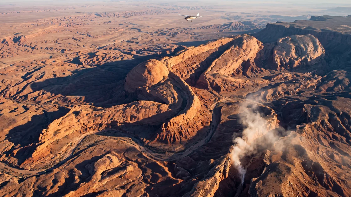
This is the account of Julian Vance, a solitary aerial survey pilot and cartographer contracted to map an unrecorded sector of the Cholla Escarpment, whose ultra-high-resolution photogrammetric scans inadvertently pierced a million years of desert erosion to reveal a monumental secret. Over weeks of flying precise grid lines in a modified single-engine aircraft and stitching billions of pixels in his isolated airfield trailer, Vance discovered that the labyrinthine gorges and fractured red-sandstone plateaus formed the unmistakable, miles-long silhouette of an anatomically perfect sleeping human form. Driven past the brink of professional detachment into a consuming obsession, Vance left his instruments behind to seek the ground truth within the labyrinth of stone, discovering that some topographies are neither dead nor entirely geological, and that certain slumbers are woven directly into the crust of the earth itself.
Chapter I: The Flight Line
The Cessna 206 Stationair smelled of avgas, heated aluminum, and the ozone tang of high-voltage electronics. Julian Vance kept his left hand loosely curled on the yoke, feeling the vibration of the Continental IO-520 through the damp palm of his flight glove, while his right hand hovered over the touch screen of the Applanix POS AV flight management system.
Below him, through a circular aperture cut cleanly into the belly of the fuselage, a medium-format camera fired at intervals of precisely two-point-four seconds. Every click of the leaf shutter was registered not as a sound, but as an imperceptible electric tremor against the soles of his boots. Tick. Tick. Tick. One hundred and fifty megapixels per exposure. Ground Sample Distance: four centimeters per pixel from an altitude of seven thousand feet above ground level.
"Line seventeen north-to-south complete," Julian murmured into the boom mic, though there was no one on the frequency to hear him. He was forty miles beyond the western hem of the Great Basin, hovering above a geologic anomaly the maps designated merely as Sector 9-South: a crumpled, deeply dislocated badland of Jurassic Navajo sandstone, red mudstone, and basaltic capstones that locals referred to as the Red Rift.
The Rift had long been avoided by county planners and commercial mineral interests alike. It was a hydrological dead-end, an alkaline wasteland crisscrossed by fissures so narrow and sheer that cattle fell into them and were never recovered, their bleating swallowed by shadows before the buzzards could even gather. Julian’s employer, a resource-exploration firm based in Reno named Terra-Vance Geospatial, had been hired by a shadowy land-holding consortium to generate an updated orthomosaic and bare-earth Digital Elevation Model (DEM) of the entire forty-square-mile tract.
Julian checked his crab angle. A persistent crosswind blew out of the northwest at twenty knots, carrying the smell of dry sage and distant alkali flats. To maintain the flight line within the two-meter lateral corridor demanded by the photogrammetric software, he had to keep the nose pointed six degrees into the wind, the plane slipping sideways through the clean, thin air like a crab skittering along the bottom of an invisible ocean.
"Cross-track error: zero-point-three meters," the synthesized voice of the navigation unit chimed in his headset. "Approaching waypoint fifty-four. Prepare for turn."
Julian pulled back smoothly on the yoke, banking thirty degrees to the east to line up on Line Eighteen. As the wing dipped, the canyon floor flared in the late-morning sun. It was an astonishingly violent landscape. Millennia of flash floods had carved the sandstone into fluted buttresses, knife-edge fins, and sprawling alluvial aprons that looked, from this height, like pools of dried arterial blood. The capstones had broken away in blocks the size of suburban strip malls, tumbling into dry washes that vanished into black subterranean slots.
He leveled out, acquired the guidance needle on the glass cockpit display, and watched the camera resume its rhythmic pulse.
Tick. Tick. Tick.
Each pass overlapped the previous by sixty percent side-lap; each forward frame overlapped the next by eighty percent forward-lap. The sheer volume of redundant optical data was staggering. When fed into the photogrammetry clusters, the software would identify tens of millions of shared tie-points between overlapping frames, calculating through sheer trigonometric brute force the exact X, Y, and Z coordinate of every pebble, juniper bush, and cliff face in the basin.
Julian had been flying survey lines for eleven years. He had mapped monoculture cornfields in Iowa that looked like green circuit boards; he had mapped suburban sprawl in Phoenix where swimming pools glittered like dropped turquoise chips; he had mapped open-pit copper mines in Utah that resembled inverted Babylonian ziggurats. But the Red Rift felt different. It was unyielding. Looking down through the glass, there were no fence lines, no cattle trails, no tire tracks from weekend dirt-bikers. There was only the immense, sun-bleached silence of the high desert, fractured into thousands of terracotta gullies.
As he reached the end of Line Twenty-two, the sun crested its zenith, eliminating the shadows that defined the relief. The earth flattened into an unreadable wash of ochre, burnt umber, and blinding bone-white. The sensors would still capture it, but the human eye lost its purchase.
"Line twenty-two terminated," he said. He switched off the camera system, closed the belly hatch to protect the anti-reflective lens coating from airborne dust, and dialed the transponder code for his descent into Tonopah.
He did not know then that the camera had already seen what his eyes could not. A camera does not interpret; it records. It does not blink; it does not turn away from the impossible because it has no concept of what is possible. It merely gathers photons, quantizes them into charge-coupled buckets of silicon, and assigns them a sixteen-bit integer of light and color. And in those integers, waiting to be assembled, lay a presence that had kept its vigil in the stone long before the first bird had split the desert air.
Chapter II: The Dense Cloud
The airfield at Tonopah was a relic of the Cold War: two cracked asphalt runways surrounded by miles of barbed wire, cheatgrass, and rusted corrugated-iron hangars that shuddered whenever the afternoon winds screamed off the Monitor Range. Julian lived in an aluminum-sided trailer parked beside Hangar Three, where he kept his plane, his tools, and his processing rig.
The rig occupied an entire wall of the trailer’s narrow interior. It was a custom water-cooled workstation with four enterprise-grade graphics cards, two hundred and fifty-six gigabytes of memory, and twenty-four solid-state drives linked in high-speed arrays. When the machine was rendering, it sounded like a turbine idling on the apron, throwing off enough heat to turn the trailer into a sauna.
It was two in the morning. Outside, the temperature had plunged to near freezing, the desert sky crowded with cold, indifferent stars. Inside, Julian sat in a worn steel swivel chair, bathed in the blue-gray luminescence of two 32-inch color-calibrated monitors. An empty mug of chicory coffee rested on a stack of USGS quadrangle sheets at his elbow.
On the left monitor, the photogrammetry suite was finishing the "dense point cloud" generation—the stage where the computer, having determined the camera positions for all nine hundred and forty frames, calculates a three-dimensional cloud of hundreds of millions of individual spatial points.
A progress bar crept across the screen: 98%... 99%... Complete.
Julian clicked the viewport to refresh.
A chaotic swarm of colored dots resolved into a three-dimensional representation of the Red Rift. Julian leaned in, his thumb hooked under his chin, his trackball scrolling smoothly to rotate the model. At this scale, viewed from an artificial perspective five miles above the digital terrain, the Rift looked like an intricately crumpled parchment.
He initiated the next step: generating the bare-earth Digital Elevation Model. The software’s algorithm ran a classification filter across the point cloud, mathematically stripping away the sparse vegetation—the gnarled pinyon pines, the saltbush, the patches of rabbitbrush—leaving only the raw, naked topography of the earth.
He toggled the view from true-color photographic rendering to an artificial hillshade model. In hillshade mode, the software simulated an artificial sun placed low on the horizon, raking light across the digitized canyons to accentuate every contour, ridge, and depression with stark black shadows.
The screen flickered as the graphics cards calculated the shadow vectors.
Julian reached for his coffee mug, found it empty, and set it down. His gaze remained locked on the center of the display.
"What is that?" he whispered.
At first, his mind attempted to categorize it within the standard lexicon of geomorphology. He looked for anticlines, synclines, monoclines, differential erosion along fault lines, or the circular signatures of collapsed calderas.
In the southern half of the Rift, where the red sandstone formed a sweeping, crescent-shaped valley sheltered by two basaltic escarpments, the terrain was wrong.
Julian dragged the cursor, centering the valley, and zoomed out until the entire survey block was visible on the screen.
It was not a random series of ridges.
The crescent valley formed the gentle curve of an arm—an arm nearly two miles long from its rounded shoulder to the delicate, segmented spurs of stone that fanned out like fingers resting against the western plateau. Above the arm, rising out of a talus slope of fragmented limestone, was the unmistakable oval of a head, tilted backward at an angle of profound, unmoving exhaustion.
Julian’s breath caught in his throat. He sat up straight, his chair squeaking sharply in the quiet room.
"Artifact," he said aloud. "A stitching error. Parallax displacement."
It happened sometimes. If the GPS data from the aircraft drifted, or if the inertial measurement unit suffered an alignment hitch during a steep bank, the photogrammetry software could duplicate features, creating strange, repetitive ghost images across the seams of the photos.
He pulled up the flight path logs. The green lines representing the aircraft’s trajectory were straight as surveyor's chalk, perfectly parallel. The IMU drift was nominal: less than zero-point-zero-one degrees of pitch, roll, and yaw. There had been no cycle slips in the satellite reception.
He switched the display back to the raw, unshaded aerial photographs—the true-color, high-resolution orthomosaic.
The silhouette vanished.
In the true-color imagery, it dissolved entirely into the bewildering chaos of the desert. The "forehead" was merely an apron of cracked caliche reflecting the white glare of the noon sun; the "closed eyelid" was a meandering fissure fifty feet deep, choked with tumbleweeds and shadows; the "lips" were two parallel ledges of iron-stained siltstone separated by a ribbon of white sand; the long, serene arch of the "spine" was nothing more than an exposed hogback ridge of dipping sandstone beds.
Julian stared, his heart hammering against his ribs like a trapped sparrow.
He toggled back to the hillshade DEM.
There it was.
Stripped of the deceptive patchwork of desert color—the red clays, the black lichens, the yellow brush—the morphology was undeniable. It was a human figure, female in its soft, swelling proportions, lying on its right side in a loose, natural fetal curl. The knees were drawn up slightly toward the chest, carved by the sweeping meander of a paleochannel. The left hip rose as an immense, rounded sandstone dome, three hundred feet above the valley floor. The face was turned slightly skyward, resting against the basalt pillow of the northern rim.
Julian zoomed in on the face.
The detail was maddening. It was not a primitive petroglyph, nor was it the crude, stylized monument of some forgotten ancient empire like the lines of Nazca or the chalk giants of Britain. Those were scratches upon the skin of the world, two-dimensional drawings meant to be viewed from above.
This was three-dimensional anatomy.
The curve of the throat was defined by an ancient drainage channel that had cut cleanly through the strata, exposing layers of lavender and vermilion clay that mimicked the subtle contours of muscle. The jawline was a continuous fault-scarp, sharp and clean, dropping seventy feet down to a floor of smooth gravel. And the face—the face was peaceful. It possessed a calm so heavy, so subterranean, that looking at it made Julian feel as though he were trespassing upon a bedchamber that had remained undisturbed since the dawn of the continent.
He checked the scale bar in the corner of the software interface.
From the crown of the head at the northern basalt wall to the tips of the toes curled into the southern sand drifts, the figure measured three point eight miles.
"Pareidolia," Julian muttered, rubbing his eyes with the heels of his hands until red sparks danced in the darkness. "You’ve been staring at pixels too long, Vance. The brain seeks itself in the gravel."
He stood up, paced the narrow length of the trailer, and opened the door. The frigid air rushed in, searing his lungs. The smell of sagebrush was sharp and clean. To the southeast, far beyond the perimeter lights of the airstrip, the jagged black teeth of the mountains rose against the stars. Somewhere out there, sixty miles into the uninhabited dark, the figure lay in the earth, its chest turned toward the sky, holding its breath beneath the weight of three hundred million years of stone.
Chapter III: Ground Truth
The photogrammetrist’s creed is simple: The image is an hypothesis; only the ground is the truth.
In professional cartography, anomalies in the model must be field-verified. If a point cloud suggests a bridge where the county maps show a ford, a technician must drive out with a survey-grade GPS rover, find the benchmark, and place the steel tip of the survey rod upon the physical earth.
Julian spent three days running tests on the dataset. He recalibrated the lens distortion parameters; he re-ran the bundle block adjustment using three different algorithms; he even imported satellite elevation data from the Shuttle Radar Topography Mission (SRTM) to serve as a coarse baseline.
Every calculation returned the same result. The geometry was real.
On the fourth morning, he loaded the back of his mud-splattered 1998 Toyota Land Cruiser with expedition gear: a Trimble R12 GNSS receiver, an optical level, four five-gallon jerrycans of water, a canvas bedroll, two weeks of shelf-stable provisions, and a printout of the hillshade DEM scaled to a topographic map at 1:24,000.
He left Tonopah before sunrise, heading south along Highway 95 until the blacktop gave way to graded gravel, then to washboard dirt, and finally to a nameless two-track trail that wound through dry alkali washes toward the jagged red wall of the escarpment.
By noon, the two-track had dissolved into a boulder-strewn canyon bed. The Land Cruiser groaned in low-range four-wheel drive, tires slipping against the loose shale as Julian climbed the outer ramparts of the Rift. The heat was relentless, shimmering over the hood in oil-slick waves that distorted the horizon.
He reached the saddle of the outer ridge by mid-afternoon. He cut the engine, stepped out into the furnace blast of the wind, and climbed a small knoll of vesicular basalt to orient himself.
He unfolded the map. According to his GPS coordinates, he was standing directly on what the digital model had rendered as the right shoulder blade of the figure.
He looked down.
There was no shoulder.
There was only a blinding, broken wilderness of stone. Below him, the terrain fell away in a series of chaotic terraces, choked with talus blocks the size of freight cars. The red sandstone was fractured by freeze-thaw cycles into razor-sharp shards that clattered like broken pottery beneath his boots. Stunted junipers grew from fissures, their trunks twisted like ropes by centuries of prevailing gales.
Julian lowered the map, a bitter wave of self-mockery washing over him.
"You fool," he said to the wind. "It’s a trick of light and distance. You’re an educated man chasing ghosts in the dust."
Up close, the human scale reasserted its dominance. A man cannot see the sculpture if he is standing upon the fingernail; he sees only the grain of the ivory. He was too small. To the ant crawling across the forehead of a sleeping child, the skin is an endless desert of pale ridges, the eyelashes are a forest of black timber, and the breath is a periodic hurricane.
Julian set up the Trimble base station on a stable rock outcrop, waiting until the receiver locked onto twelve satellites, chirping its quiet confirmation of centimeter-level accuracy. He slung the rover rod over his shoulder, took up his geological hammer and canteen, and began to pick his way down into the canyon.
He wanted to reach the face.
According to the map, the feature that corresponded to the mouth—the slot canyon where the lips met—was two miles to the north, down in the lowest depression of the valley floor.
The descent was brutal. The sandstone was friable, breaking away under his weight in showers of red dust that stained his jeans and settled into the creases of his skin. The heat gathered in the floor of the Rift like water in a kettle, thick and breathless, smelling of scorched mineral and old sulfur. There were no animal tracks here—no sheep, no coyotes, not even the scuttling prints of the fringe-toed lizard.
After two hours of scrambling through dry chutes, he reached the mouth of the slot canyon.
The walls here were sheer, rising ninety feet on either side, composed of deep crimson siltstone so smoothly polished by prehistoric water that they seemed almost varnished. The canyon was narrow—barely ten feet across at the entrance—and within its depths, the temperature dropped twenty degrees into a cool, purple gloom.
Julian stepped inside. The silence was immediate and heavy, broken only by the crunch of his boots on the white quartz gravel that lined the floor.
He walked five hundred feet into the fissure. The walls twisted in graceful, serpentine curves, undulating like curtains of silk frozen into stone. He ran his hand along the rock. It was cold to the touch, silky and fine-grained, with thin veins of white calcite tracing intricate networks through the red base.
He stopped.
Ahead, the slot canyon narrowed until it was barely wide enough for a man to squeeze through sideways. Through this slit, a faint draft was moving. It did not blow with the erratic gusts of the upper desert; it was a rhythmic, continuous exhalation, smelling faintly of wet slate and something else—something sweet and ancient, like the scent of petrichor on soil that had not seen rain in a geological age.
Julian held his breath and listened.
The wind was whistling through the narrow gap. But it was not a single tone. It was a chord—three low, resonant frequencies vibrating deep in the register, so low that he felt them in the cartilage of his chest rather than his ears.
Huuuummmmmmm-ah.
Julian froze, his hand pressed flat against the rock wall.
The stone was vibrating.
It was an infinitesimal oscillation, so faint that had he been moving, he would have missed it entirely. But standing motionless in the dark, his palm flat against the cool calcite vein, he felt it distinctly: a pulse.
One.
Then a long, agonizing silence that lasted nearly forty seconds.
Two.
"Subterranean resonance," Julian said, his voice cracking in the still air. "An underground aquifer. Magmatic displacement along the basin fault."
He took out his geological hammer and tapped the wall. Clink. The sound was dull, deadened by the immense mass of the mountain surrounding him.
He pushed his way into the narrow slit, his shoulders grazing the stone on both sides. The rock was slick, almost greasy with some microscopic talc-like powder. After twenty feet, the crevice opened into a hollow chamber—an amphitheater buried deep within the heart of the sandstone bluff.
Julian switched on his headlamp.
The beam cut through the absolute darkness, illuminating a ceiling that arched forty feet overhead in a perfect, smooth dome. The floor was composed of a single, continuous sheet of black basalt, polished to a mirror sheen, perfectly horizontal, as level as the surface of a mercury pool.
And in the center of the basalt floor lay a mound of red sand.
Julian approached it slowly, the beam of his headlamp trembling with the motion of his steps. The mound was five feet long, shaped like a slender spindle. As he drew nearer, he saw that the sand had not been piled by the wind. The grains were arranged in concentric, alternating rings of crimson garnet and white quartz, radiating outward from a central point like the growth rings of an ancient tree.
He knelt beside the mound. He reached out a finger to touch the sand, but stopped three inches away.
The air above the mound was warm.
It rose in a delicate, shimmering plume of thermal distortion, visible in the sharp beam of the LED lamp. Julian hovered his bare hand over it. A gentle, pulsing warmth beat against his skin, perfectly synchronized with the deep, forty-second vibration he had felt in the canyon wall.
Julian knelt there in the dark, four hundred feet beneath the surface of the desert, and for the first time in his rational, measurement-driven life, he felt the terrifying vertigo of an intellect realizing that the tool it holds is too small for the universe it is trying to measure.
Chapter IV: The Archival Ghost
Julian did not sleep that night. He sat in the cab of the Land Cruiser on the high ridge, the doors locked, the windows rolled up against the wind that howled across the basalt plateaus. The hillshade map lay crumpled on the passenger seat like an unexploded shell.
By daybreak, he had made his decision. He did not return to the slot canyon. Instead, he drove back down the escarpment, the suspension taking punishment it was never designed to endure, and pointed the truck north toward Reno.
Terra-Vance Geospatial occupied a low, glass-fronted office park near the Reno-Tahoe International Airport. Its halls were lined with framed satellite mosaics of open-pit silver mines and infrared maps of timber concessions. The air smelled of carpet cleaner and ozone from the server rooms.
Julian did not go to his desk. He went down the basement stairs to the archives, where the company maintained the physical collections of its predecessor firms—thousands of rolled linen maps, surveyor’s field notebooks bound in calfskin, and glass-plate negatives dating back to the late nineteenth century.
The archivist was a woman named Eleanor Vance—no relation to Julian, though they had shared jokes about it over the years. She was seventy-two, with silver hair pinned back with a steel drafting compass, and fingers stained permanently yellow from cigarette smoke and nitrate film chemistry.
"Julian," she said without looking up from her light table, where she was examining a 1948 aerial print of the Carson Sink. "You look like you’ve been dragged through a gravel crusher. Did you finish the Red Rift orthos?"
"I need the historical records for Sector Nine-South," Julian said. He stood in the doorway, his boots still caked with red silt, his eyes rimmed with red veins.
Eleanor looked up, her glasses slipping down her nose. She studied his face for a long moment.
"Sector Nine-South," she repeated slowly. "The Cholla block. Nobody asks for that."
"What do we have on it?"
"Nothing digital," she said, leaning back in her chair. "When we migrated the library to the cloud back in '08, Sector Nine was flagged as dead data. No mineral claims, no water rights, no BLM grazing permits. Why? What did you find out there? Uranium?"
"Show me the paper," Julian said.
Eleanor sighed, pushed herself up from the table, and led him into the deep vaults at the rear of the basement. The shelves here were heavy industrial steel, laden with grey archival boxes that held the forgotten geography of the American West: the maps made by men who had died of thirst, dysentery, and madness while trying to turn a continent into rectangles.
She stopped at a row labeled Wheeler Survey / King Survey: Unorganized Territories (1871–1879).
She pulled down a long, narrow box covered in black buckram, blew a cloud of dust from its lid, and set it on a metal counter. Inside were several tubes of tin, sealed with beeswax.
"George Wheeler’s expedition passed south of the Rift in 1872," Eleanor said, using a bone folder to scrape the wax from the seal of the largest tube. "They had two topographers and an artist named Timothy O’Sullivan. O’Sullivan carried an eighty-pound wet-plate camera into places where mules couldn't walk."
She slid a rolled parchment from the tube and flattened it under four lead weights.
The map was hand-drawn in sepia ink, the mountains rendered in exquisite, hair-fine hachuring that gave the topography the look of muscle fibers stripped of their skin. It was titled: Preliminary Reconnaissance of the Red Badlands, Intermountain Region, Nevada Territory.
Julian leaned over the parchment. His eyes darted across the margins, past the elevation benchmarks and the notes on alkaline springs, until he found the crescent valley.
The valley was there. The hachures clustered tightly along the northern rim, showing the basalt wall.
Across the center of the valley, written in the meticulous, spidery hand of a nineteenth-century military cartographer, were three words:
Terra Dormiens Incognita.
Below it, in the space usually reserved for notes on timber and forage, the topographer had written a brief marginalia:
September 14, 1872. Lieut. C. R. Miller commanding. We have halted our approach at the western wash. The native guides (Northern Paiute) refuse absolutely to enter the basin, stating that to walk upon the ground here is to walk upon the flesh of the Elder Mother who rested after the tearing of the sky. They believe that her breath maintains the salt of the earth, and that should she be awakened by the striking of iron or the measuring of chains, the valleys will close like eyelids and the mountains will stand upon their heads. The topographer noted an extraordinary optical deception from the high ridge: the drainage networks present the curious and unsettling aspect of a human form of gigantic proportion. We did not advance further, our compasses suffering from severe local disturbance.
Julian reached out with a trembling finger, tracing the faded ink of the word Dormiens.
"Eleanor," he said softly. "Has anyone else ever looked at this?"
"Not in the forty years I’ve been here," she said. "Except once. In the seventies. An old man from the Department of Defense. He wasn't interested in the topography, though. He was looking for magnetic anomalies. He spent two hours down here, made a phone call from the lobby, and three days later the federal government classified the aerial reconnaissance film from the U-2 flights over that sector."
She looked at Julian, her gaze piercing and steady.
"Julian, whatever is out there, it isn't yours to find. Topography isn't just lines on a screen. Sometimes the land is shaped a certain way for a reason. If you go pulling at the thread, the whole carpet comes up."
Julian didn't answer. He took his phone from his pocket, photographed the margin note, and turned toward the stairs.
"Julian," Eleanor called after him.
He stopped at the foot of the concrete steps, the shadows of the basement hanging over him.
"Don't go back out there with the instruments," she said, her voice dropping to a whisper. "The old surveyors knew when to put the chains away. Some things only stay asleep if you don't name them."
Chapter V: The Second Pass
Julian did not obey her.
The cartographer’s madness is different from the gold-miner’s or the conqueror’s. It is not greed that drives him, nor the desire for mastery. It is the intolerable existence of the unresolved. It is the itch of the blank space on the map, the blank space that is worse than an error because an error can be corrected, while an ambiguity rots the mind.
He returned to Tonopah that same night.
He did not sleep. He spent eighteen hours in the hangar, stripping the Cessna of every ounce of non-essential weight. He removed the co-pilot’s seat, the rear bench, the emergency survival kit, and the auxiliary fuel tank. In their place, he installed a borrowed high-resolution Riegl VUX-1UAV LiDAR scanner alongside the Hasselblad photogrammetric rig.
LiDAR would not rely on ambient sunlight. It was an active sensor. It would fire three hundred thousand pulses of near-infrared laser light per second at the canyon floor, timing their return to within picoseconds. It would pierce the shadows of the slot canyons, penetrate every crack in the sandstone, and return a point cloud of such terrifying, surgical density that no optical trick could survive its gaze.
He took off at 4:30 AM, an hour before the first hint of dawn.
The desert below was a void of pitch, the cold air smooth as glass. As the aircraft climbed through eight thousand feet, the horizon to the east began to bleed a pale, bruised violet.
Julian leveled out over the southern coordinates of the Red Rift.
He waited for the sun.
He wanted the light raking at zero degrees—the exact moment the sun’s disc touched the horizon, throwing shadows that were miles long, turning the smallest pebble into an elongated spire of ink.
"Sensors armed," he said. His voice was hoarse, dry from too much coffee and the thin air of the cabin. "LiDAR initialized. Pulse rate maximum."
The eastern sky flared from violet to brilliant amber. A solitary spark of raw, golden light cracked the rim of the Monitor Range.
Julian initiated the run.
He flew lower this time: three thousand feet above the canyon floor. The Cessna bucked violently as the morning thermals began to tear off the sandstone ridges like rising ghosts. He fought the controls, his teeth clenched, keeping the crosshairs pinned to the navigation line.
Below him, the miracle occurred.
In the extreme low-angle light of the dawn, the colors of the desert were submerged beneath the architecture of the shadows. The Red Rift transformed.
Through the side window, Julian looked down.
He was flying directly over the chest.
The morning light caught the southern escarpment, casting a shadow that reached across the entire floor of the crescent valley. But it was not a flat shadow. It draped over the topography like a dark wool blanket over a sleeping body, clinging to the curve of the ribs, dipping into the soft depression of the belly, rising over the swell of the hip.
And as the light crept forward, foot by foot, across the stone, Julian saw the movement.
It was not an earthquake. It was not a slide of talus.
It was an expansion.
The chest of the figure—the three-mile-wide plateau of crimson sandstone—was rising.
Julian gripped the yoke with both hands, his knuckles turning white as chalk. He stared through the windshield, his eyes wide, refusing to blink.
The movement was slow, monumental, measured in feet rather than inches. The entire valley floor groaned—a sound that rose above the roar of the Continental engine, a deep, grinding tectonic sigh that vibrated through the metal frame of the aircraft, rattling the instrument panel and sending the artificial horizon spinning in its gimbal.
The ridge that formed the ribcage lifted six feet, the shadows stretching and shifting like muscles beneath taut skin.
Then, at the apex of the rise, the slot canyon—the lips—parted.
A cloud of white dust, fine as flour and vast as a storm front, erupted from the narrow slit in the stone. It rose vertically into the clear dawn air, forming an enormous, billowing plume that caught the golden sunlight and turned into a pillar of fire.
The wind hit the Cessna like a solid fist.
The aircraft was thrown upward three hundred feet in two seconds, the stall warning horn screaming its shrill, brassy note in the cockpit. Julian pushed the nose down with all his weight, the G-forces lifting him out of his seat, his head striking the cabin roof.
The flight computer was screaming: Warning: Terrain. Pull Up. Terrain.
He did not look at the instruments. He looked down through the aperture in the floor.
The LiDAR screen on the passenger console was painting the real-time point cloud in shades of electric green and neon blue. Millions of points cascaded down the screen like a digital waterfall.
The model was not showing rocks.
Beneath the thin, weathered veneer of sandstone—beneath the twenty feet of Jurassic sediment that the laser pulses were penetrating through the fractures—the system was mapping a lattice of bone.
Massive, porous, cellular structures, fossilized into high-density ironstone, but retaining every canal, every marrow-space, every delicate, sweeping curvature of human skeletal anatomy. The spine was not a hogback ridge; it was a column of thirty-three articulated vertebrae, each one the size of a cathedral, linked by discs of compressed bitumen.
And within the skull—beneath the basalt capstone of the northern plateau—the laser was tracing the intricate, convoluted folds of a brain carved from solid nephrite, its fissures filled with veins of native copper that pulsed with a faint, rhythmic electromagnetic charge.
The figure was not a statue.
It was not a monument.
It was a body that had been buried in the silt of an inland sea three hundred million years ago, before the first dinosaur had walked, before the ferns had turned to coal, before the continent had split from the ancestral crust of Pangaea. It had lain there while the oceans rose and retreated, while the mountains were pushed up like crumpled paper and ground down into dust, waiting for the weight of the stone to wash away, grain by grain, under the patient chisel of the rain.
And now, the skin was exposed.
The Cessna caught another updraft, the wings groaning as the rivets strained against the sheet metal. Julian fought the controls, banking away from the rising dust plume that now smelled overpoweringly of wet slate, ozone, and the warm, terrifying breath of a creature whose dreams were the earthquakes of the Great Basin.
"Log terminated," he screamed into the dead mic. "Turn off the cameras! Turn them off!"
He reached out, his hand shaking so violently he could barely strike the master switch, and severed the power to the sensors.
The screens went black. The Riegl scanner spun down with a dying metallic whine.
Julian banked the plane hard toward the west, flying toward the blinding safety of the morning sun, his compass spinning erratically, his instruments blind, while behind him, across forty square miles of fractured red sandstone, the great sleeper began, infinitely slowly, to turn upon its other side.
Chapter VI: The Erasure
Julian did not land at Tonopah.
He flew past it, watching the cracked runways and the little aluminum trailer slide beneath his wing like the detritus of a past life, and continued west across the snow-capped spine of the Sierra Nevada. He did not speak to air traffic control; he flew low, skimming the tree lines of the passes, until he reached the small municipal airstrip at lone pine, California, tucked into the deep shadow of Mount Whitney.
He landed with six gallons of fuel remaining in the main tanks.
He shut down the engine. The silence that rushed into the cockpit was absolute, broken only by the ticking of the cooling exhaust manifold.
Julian sat in the seat for an hour, his hands resting on his knees. Then he stood up, unlocked the equipment bay, and unbolted the hard drives from the processing computer and the LiDAR unit.
He carried them into the hangar office. There was a cast-iron woodstove in the corner, used to heat the drafty shed during the winter months. He opened the iron door, threw in three pine logs and a cup of kerosene, and dropped a match onto the wood.
The fire caught with a soft whump.
Julian took the drives—the four terabytes of raw photogrammetric data, the billion points of the LiDAR point clouds, the precise GPS tracks, the calibration files—and placed them one by one into the heart of the flames.
The aluminum enclosures warped; the circuit boards bubbled, releasing a bitter, chemical stench of burning resin and solder; the magnetic platters inside the enterprise drives buckled and flaked away into carbon.
He watched them burn until there was nothing left but a charred mass of slag resting in the ash.
Two days later, Julian walked into the offices of the Esmeralda County Assessor in Goldfield, Nevada. He carried with him a single sheet of paper: the official completion certificate for the survey of Sector 9-South.
Attached to the certificate was a map he had drawn by hand during his two nights in Lone Pine.
It was a masterpiece of professional deceit.
He had smoothed the contours. He had turned the long, graceful curve of the arm into a series of jagged, uninteresting box canyons. He had broken the serene oval of the head into a chaotic field of ordinary talus slopes. He had shifted the drainage lines by fifty meters here, a hundred meters there, introducing just enough random error, just enough topographic noise, that any algorithm processing the map would see only what the geologists expected to see: a barren, eroded, useless labyrinth of late-Jurassic sandstone, structurally unstable and devoid of economic value.
He handed the paper across the counter to the clerk, an elderly woman with bifocals who stamped it without looking up.
"Everything in order, Mr. Vance?" she asked.
"Everything is in order," Julian said. "The sector is barren. There's nothing out there."
"Good," she said, sliding the file into a steel drawer. "We've got enough wasteland in this county without people finding things to argue about."
Chapter VII: The Cartographer’s Eye
Julian Vance never flew again.
He sold his Cessna to a flight school in Bakersfield, surrendered his commercial pilot’s license, and bought a small stone cabin on the eastern slope of the Inyo Mountains, forty miles west of the Red Rift.
From his porch, through a brass nautical telescope mounted on a tripod, he can look across the Owens Valley and the white alkali flats toward the distant, hazy line of the Cholla Escarpment.
He knows that if a man looks at the mountains through a telescope, he sees only rock, scrub, and shadow. He knows that if a man looks at the satellite imagery on his computer, he sees only what the algorithm has been instructed to assemble from the fragments of light.
The world protects itself. Its scale is its armor. It is too vast to be seen by those who stand upon it, and too broken to be understood by those who look from above with hurried eyes. Only the flight line—the patient, repetitive, mechanical tracing of the air—can accidentally stumble upon the grand design; and only the mapmaker knows how much must be erased in order to keep the world safe for the living.
Sometimes, in the dead of winter, when the north wind scours the desert clean of dust and the air is as clear as cut crystal, Julian sits on his porch in the deep dark before the dawn.
He does not need his maps. He does not need the LiDAR point cloud.
Every contour of that three-mile body is burned into the retinas of his memory: the sweep of the hip, the tucked knees, the quiet arch of the throat, and the long, stone fingers resting upon the sand.
At 5:12 AM, the first light of the sun touches the northern escarpment.
Julian leans forward, his eye pressed to the telescope.
He watches the slot canyon.
He waits for the plume of white dust.
And when it rises—a thin, straight column of ivory smoke ascending five thousand feet into the rose-colored sky, drifting southward across the sleeping face like a veil of lace—Julian Vance takes a slow, deep breath of the cold mountain air, feeling his own chest rise and fall in the same ancient, terrible measure, and whispers into the dawn:
"Sleep well."